

. See source website for additional information. This set of images was gathered by User:Dcoetzee from the National Portrait Gallery, London website using a special tool. All images in this batch have been confirmed as author died before 1939 according to the official death date listed by the NPG. Date Unknown, but author died in 1904 Source National Portrait Gallery, London: NPG 923 While Commons policy accepts the use of this media, one or more third parties have made copyright claims against Wikimedia Commons in relation to the work from which this is sourced or a purely mechanical reproduction thereof. This may be due to recognition of the")
Source: Courtesy of Wikimedia Commons
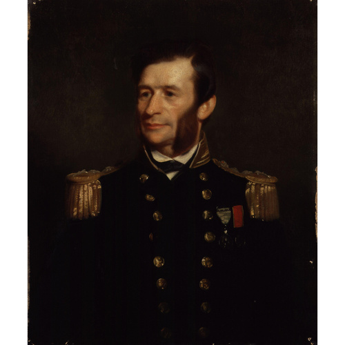
RICHARDS, Sir GEORGE HENRY, naval officer, surveyor, explorer, and hydrographer; baptized 27 Feb. 1819 in Antony, Cornwall, England, son of George Spencer Richards, rn, and Emma Jane —; m. first 1 March 1847 Mary Young (d. 1881), and they had four sons and one daughter; m. secondly 1882 Alice Mary Tabor; d. 14 Nov. 1896 in Bath, England.
George Henry Richards entered the Royal Navy in 1832, serving first in the West Indies and then, under Edward Belcher*, in the Pacific. After winning commendation for bravery in the first Opium War with China (1839–42), he was promoted lieutenant on 12 July 1842 and assigned to the navy’s survey of the Falkland Islands. In hostilities with the Republic of Buenos Aires (Argentina), he won promotion to commander, and from 1847 to 1851 he participated in the survey of the coasts of New Zealand. In 1852–54 he served as second in command on Belcher’s ship Assistance in the search for Sir John Franklin*, whose Arctic expedition had been missing since 1845. In the summer of 1853 Richards again distinguished himself, this time by making several journeys by sledge, covering about 2,000 miles in a period of seven months. On one voyage, from Northumberland Sound (N.W.T.) to Dealy Island, he visited Captain Henry Kellett*’s ship Resolute. Upon his return to England in 1854 he was promoted captain.
In 1856 Richards was given command of the screw survey vessel Plumper, which was being sent to the Pacific northwest to assist the Anglo-American boundary commission [see Samuel Anderson*] and to provide a British military presence on Vancouver Island [see Sir Robert Lambert Baynes*]. The ship reached Esquimalt on 10 Nov. 1857, five months after the arrival of senior British commissioner Captain James Charles Prevost. Richards, as second commissioner for the maritime boundary, was to make a detailed survey of the waters between Vancouver Island and the American mainland, to help determine the location of the international boundary through the San Juan Islands. The survey was completed in June 1858, and in the next few months Richards met with his fellow commissioners in a vain attempt to settle the boundary (the deadlock would not be broken until 1871–72). The main problem was the unyielding position of the American commissioner, Archibald Campbell, whom Richards in October described to the hydrographer of the navy as “impossible to deal with unless given everything he asks.” In his field-book Richards had noted in August that he was “Sick of all commissions. Nothing but trickery and humbug.”
Other work awaited Richards, for by the end of June 1858 more than 14,000 gold-miners from California had arrived in Victoria, anxious to reach the Fraser River gold-fields. It was imperative that the Plumper examine and buoy the lower stretches of the Fraser. The colonial authorities also required the assistance of Richards and his ship to provide transportation and manpower, and occasionally to help maintain law and order among the miners. In a letter of 21 Dec. 1859 Richards observed that because of these unforeseen demands “we have scarcely yet put on the character of a surveying ship.” Plumper, however, with its maximum speed of 6½ knots, was inadequate for an area where tides could run at 8 knots. While awaiting a larger vessel, Richards completed surveys of the Fraser River up to Harrison Lake, of the coast of Vancouver Island from Nanaimo north to Cape Lazo, and of Victoria, Nanaimo, and Cowichan harbours.
On 23 Dec. 1860 the Hecate, a paddle-sloop, arrived at Esquimalt to replace the Plumper, which then returned to England. Most of Richards’s officers elected to remain with him. With this experienced team, the Hecate, and as many as seven small boats working away from the larger ship for up to two weeks at a time, good progress was made between 1860 and 1862 on the survey of the rugged coasts of Vancouver Island and the adjacent mainland of British Columbia. At times Richards was obliged to interrupt his surveying when called upon by Governor James Douglas* to deal with conflicts between whites and coastal Indians. Naval units were often sent to remote Indian villages to investigate complaints or arrest suspects in such incidents, which Richards and others blamed mainly on the whites.
Richards was tireless in sending charts, nautical instructions, and a wide range of observations to England, urging the Admiralty to print as soon as possible his sailing directions for the straits of Juan de Fuca and Georgia since numbers of ships were entering the straits “really knowing nothing of the navigation, and run considerable risks.” The Admiralty’s Hydrographic Office published the Vancouver Island pilot in two editions, in 1861 and 1864, compiled mainly from his surveys. When, in December 1862, Richards and the Hecate sailed for England by way of the Cape of Good Hope, his senior assistant surveyor, Daniel Pender, stayed behind to continue surveying the British Columbia coastline.
On his return to England in January 1864, Richards found he had been appointed hydrographer of the navy. In this position he once again gave outstanding service. He was not only an experienced surveyor and a fine administrator, but an active promoter of oceanographic research. Upon his retirement in 1874, he was made managing director of the Telegraph Construction and Maintenance Company which, under his direction, laid thousands of miles of submarine telegraph cables. A fellow of the Royal Society and of the Royal Geographical Society, Richards was knighted in 1877 and reached the rank of admiral in 1884.
British Columbia was fortunate to have a man of the calibre of George Henry Richards assigned to survey its coast. His hydrographic work was of the highest quality, making him a worthy successor to George Vancouver*, whom he obviously admired, having named one of his sons after him. In his obituary in the Proceedings of the Royal Society, Richards is described as “a man of great ability, of sound commonsense, and of untiring activity, and his unfailing good humour, general shrewdness, and kindness to young members of his profession caused him to be universally beloved and respected.”
[Richards’s surveys of Vancouver Island form the basis of G.B., Hydrographic Office, Vancouver Island pilot; part I: sailing directions for the coasts of Vancouver Island and British Columbia, from the entrance of Juan de Fuca Strait to Burrard Inlet and Nanaimo Harbour (London, 1861) and its Supplement (1864), and much of The Vancouver Island pilot, containing sailing directions for the coasts of Vancouver Island, and part of British Columbia . . . (London, 1864). The Hydrographic Office also issued a two-volume French translation of the 1864 edition, Pilote de l’île Vancouver; routes à suivre sur les côtes de l’ île Vancouver et de la Colombie-Anglaise . . . , trad. M. Hocquart (Paris, 1867).
Richards’s manuscript letter-book (1857–62), field notebook (1858–62), and captain’s journal, Vancouver Island survey (1860–62), remain in private hands in England. The author was permitted to consult these papers but is not at liberty to disclose their location.
A photograph of Richards held by the PABC, Visual Records Division, is reproduced on the cover of British Columbia Hist. News (Vancouver), 19 (1986), no.2. h.b.a.]
G.B., Ministry of Defence, Hydrographic Dept. (Taunton, Eng.), Misc. papers, 20, folder 3, no.2. PRO, ADM 1/ 5699; 1/5736, pt.ii, Y152. Scott Polar Research Institute (Cambridge, Eng.), ms 768 (G. H. Richards, journal aboard H.M.S. Assistance, 1853–54). Geographical Journal (London), 9 (1897): 97–98. G.B., Parl., Command paper, 1859 (2nd session), 22, no.2578: 297–408, Papers relative to the affairs of British Columbia, part II . . . , esp. 317–26. Times (London), 17 Nov. 1896. Walbran, B.C. coast names. Stanley Fillmore and R. W. Sandilands, The chartmakers: history of nautical surveying in Canada (Toronto, 1983). J. O. McCabe, The San Juan water boundary question (Toronto, 1964). Alec McEwen, “A guardian of the boundary,” British Columbia Hist. News, 19, no.2: 5–8.
Image Gallery

Cite This Article
Helen B. Akrigg, “RICHARDS, Sir GEORGE HENRY,” in Dictionary of Canadian Biography, vol. 12, University of Toronto/Université Laval, 2003–, accessed December 31, 2025, https://www.biographi.ca/en/bio/richards_george_henry_12E.html.
The citation above shows the format for footnotes and endnotes according to the Chicago manual of style (16th edition). Information to be used in other citation formats:
| Permalink: | https://www.biographi.ca/en/bio/richards_george_henry_12E.html |
| Author of Article: | Helen B. Akrigg |
| Title of Article: | RICHARDS, Sir GEORGE HENRY |
| Publication Name: | Dictionary of Canadian Biography, vol. 12 |
| Publisher: | University of Toronto/Université Laval |
| Year of publication: | 1990 |
| Year of revision: | 1990 |
| Access Date: | December 31, 2025 |