

![Original title: Le Fort Rémy, 1671. D'après le plan de M. de Catalogne [image fixe] / Gédéon de Catalogne](/bioimages/w600.4529.jpg "Le Fort Rémy, 1671. D'après le plan de M. de Catalogne [image fixe] / Gédéon de Catalogne")
CATALOGNE, GÉDÉON (DE) (he signed “Catalougne,” the Béarnais way, but most official documents refer to him as “Catalogne”; he used the particle “de” sometimes, whereas some of his relatives used it and some did not), surveyor, cartographer, and sub-engineer; b. 11 Nov. 1663 and baptized seven days later at Arthez (Arthez-de-Béarn), France, son of Gédéon Catalougne and Marie de Capdeviolle, grandson of Gédéon Catalougne; m. 11 Aug. 1690 at Montreal Anne Lemire, daughter of Jean Lemire* and Louise Marsolet, and they had nine children, including Joseph; d. 5 July 1729 at Louisbourg.
In his youth, Catalogne must have been instructed in mathematics, particularly geometry; but, being a Protestant, he could not have been trained for a commission in the corps of engineers. Evidently he came to Canada in 1683 under the nom de guerre of “La Liberté,” serving as a soldier and surveyor in the colonial regular troops and taking part in both Le Febvre* de La Barre’s campaign against the Iroquois (1684) and the attacks against English posts on Hudson Bay led by the Chevalier de Troyes* (1686). In 1687, after his conversion to Roman Catholicism, he was commissioned. As an ensign, he participated in several campaigns against the Iroquois and the English, including the siege of Quebec led by Phips*, and supervised the construction of various earthworks and stockade fortifications. After being promoted in 1691, at Buade* de Frontenac’s request, to the rank of half-pay lieutenant, he continued his surveying, building, and general military duties; and Bochart de Champigny described him as a “good officer and honnête homme.” In 1700, as a licensed surveyor, he undertook for 9,000 livres to construct a canal at Lachine for the Sulpicians [see Dollier de Casson]; but his survey must have been inadequate for, among other things, he did not foresee the large amount of solid rock which would have to be excavated and removed. The canal was not finished.
He became a lieutenant in 1704, took part in the raid led by Auger de Subercase in 1705 against St John’s, Newfoundland, and helped to strengthen the colony’s defences on the Richelieu River invasion route. Most important during the war of 1703–13, however, was his detailed mapping of the three administrative districts of Canada, beginning about 1708 and culminating in the well-known survey reports of 1712 and 1715. During the same period he sought recognition from the Académie des Sciences for two scientific papers: one in 1706 on longitude and the drift of ships and the other in 1710 on a method of taking soundings; the academy was unable to adopt them. The intendants, Jacques and Antoine-Denis Raudot, who were most impressed with his work, recommended a captaincy for him; but the court would do no more than name him sub-engineer, with a supplementary salary of some 200 livres per annum. He held this post at Montreal from 1712 until 1720, preparing plans and maps, and directing work on the enceinte, and occasionally assisting with the works at Quebec. Slowly he moved up the seniority list until, by 1720, he was second in line for a captaincy.
That year the Comte de Saint-Pierre, proprietor of Île Saint-Jean (Prince Edward Island), asked for Catalogne, “an excellent person, who understands the work that has to be done and is more suitable than any other for such a settlement.” He assisted Saint-Pierre until 1723, when he finally received the promotion he had been seeking: a captaincy and command of one of the companies at Louisbourg; but he lost the status – and pay – of sub-engineer. While in Canada settling various property transactions in 1722–23, he joined master-builder Jean-Baptiste Maillou*, dit Desmoulins, of Quebec, with the object of underbidding Michel-Philippe Isabeau for some of the works at Louisbourg. He was sure, he told the minister in November 1724, that far from conflicting with his military responsibilities such a partnership would be in the interests of the service – in addition to providing the supplementary income which Catalogne required to support his large family still in Canada.
Naturally the climate of Île Saint-Jean appealed to Catalogne more than that of Louisbourg; he could not think of a better arrangement than to command a company on the island. Therefore, after nothing had come of Maillou’s bid, Catalogne informed the minister that the people of the island, which had been returned to the royal domain, wanted him to take command. He could do that economically, he suggested, if he were paid a flat sum for feeding and clothing his company, by purchasing supplies for the lowest possible Louisbourg price and keeping them for two years in storehouses built large enough for the purpose. The minister, however, had no plans for raising the tiny garrison of Île Saint-Jean to company strength, nor was he impressed with Catalogne’s plan.
Catalogne was too enterprising to be satisfied with garrison life at Louisbourg. He had acquired, on the Miré (Mira) River, property which he was developing both for its limestone quarries and for its fertile soil: on it he was growing barley, oats, several kinds of vegetables, melons, and tobacco. At his own expense he had found that agriculture in certain districts of Île Royale (Cape Breton Island) was possible but costly if scarce hired labour were used; but the Miré, he said, could support 500 resident families, and livestock could be imported and bred there with profit.
At his death in 1729, Catalogne held property in Louisbourg, on the Miré, in Quebec, and in Montreal; the Quebec property was the fief of Les Prairies-Marsolet, first conceded to his wife’s grandfather, Nicolas Marsolet*. The Montreal property on the Saint-Pierre River was acquired from the Sulpicians in 1690. It was natural for the author of the 1712 and 1715 reports, a surveyor, to place a high value on land, but the total economic worth of his own holdings remains unknown.
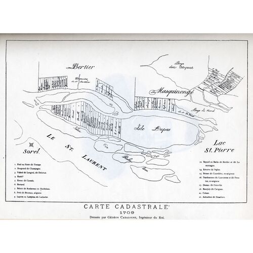
His most important legacies are his maps and plans, his reports of 1712 and 1715 on the seigneuries and his Recueil de ce qui s’est passé au Canada, au sujet de la guerre tant des Anglais que des Iroquois, depuis l’année 1682. Although not all of Catalogne’s maps and plans have survived, and although some for which he was responsible may not have been attributed to him, there are extant a map of the district (“gouvernement”) of Quebec in three parts and one of the district of Trois-Rivières in two. All dated 1709 and drawn by Jean-Baptiste de Couagne, they illustrate the corresponding portions of the 1712 survey report by Catalogne on the seigneuries by showing the boundaries of the grants and the names of the seigneurial families. Those of the district of Montreal are missing. Other maps extant are a plan of Montreal and a map of the St Lawrence River in two parts, drawn by Catalogne and published in 1723 in Paris by king’s geographer Moullart Sanson. There is also evidence that Catalogne drew a plan of Chambly in 1711 and one of the enceinte of Montreal in 1715.
Catalogne’s survey of the seigneuries, the first version of which was dated 1712 and which was revised in 1715, arose from a study finished in 1708 which was limited to the district of Montreal. Catalogne, who had undertaken the work himself with support from the elder Raudot, asked the minister whether the king would like him to survey the seigneuries of the whole of Canada. Pontchartrain thought that the task might be shared with Levasseur de Neré and Dubois* Berthelot de Beaucours; but the Raudots, to whose discretion the matter was left, preferred to have Catalogne do the whole job himself. Some of the shortcomings of the report may stem directly from this decision, as Catalogne was required to attend to his other duties at the same time; in fact he pleaded lack of time for failing to show the total area of land under cultivation and for omitting certain seigneuries.
The report set out to survey Canada district by district and seigneury by seigneury, indicating “ . . . both the natural and the adventitious products, and the quality and ownership of the lands.” It was observed that many seigneuries had not been developed, thus confirming that which had influenced Versailles in issuing the edicts of 1711 ordering the return of undeveloped seigneuries to the king and of undeveloped rôtures to the seigneur. Catalogne made no attempt to describe the undeveloped lands, however, or to ascribe reasons for their primitive state. The revision of 1715 (which, unlike its predecessor, has not been published) corrected some errors and specified “the seigneuries on which justice is administered”; but its main object was to make the paper more practical: to emphasize improvements which could really be carried out. These reports were, however, no panacea: they provided topographical and resource information, at least some of which was new to the administrators and policy-makers of the time.
The Recueil is partly a chronicle based on hearsay and partly a memoir, with all the defects and the usefulness of these types of sources: subjectivity and errors in recollection, but details which complement contemporary documents. Written no earlier than the autumn of 1716, it is a version of events from 1682 until that year. It is of value for the details it provides of those events, particularly military, in which Catalogne took part, such as the raids on the James Bay forts in 1686 and on St John’s in 1705, and it is interesting for the character assessments which Catalogne makes of some of his contemporaries. In other respects, it must be read with caution.
[The maps and plans attributed to Catalogne are to be found in the British Museum and the Bibliothèque Nationale, with copies in the Public Archives of Canada, Ottawa. Another map, of Montreal, in the Archives du Comité Technique du Génie (Paris) may or may not be attributable to Catalogne, and there is speculation as to whether the Montreal plan of 1723 (see below) is a copy, reduced, of the missing one of 1707 (article of Mme M. Azard, cited below).
The Recueil is to be found in AN, Col., F3, 2, ff.100–29. It was published in Le Blant (see below), pp.170–272, and previously in less accurate and incomplete versions dated 1871 (Société Historique et Littéraire de Québec) and 1883 (in Coll. de manuscrits relatifs à la N.-F., I). The nature of the two earlier publications is described in Le Blant, pp.154–56.
AJM, Greffe de Jacques David, 28 juillet 1721, 22 sept. 1721; Greffe de Claude Maugue, 24 oct. 1692; Greffe de J.-B. Pottier, 2 févr. 1690, 9 août 1690, 31 oct. 1700; Greffe de J.-C. Raimbault, 19 juin 1726, 25 août 1728, 31 août 1728, 15 févr. 1730, 26 juin 1730, 9 août 1731, 13 mars 1732. AJQ, Greffe de François Genaple, 3 juin 1696. AN, Col., B, 29, ff.124v, 334v, 335f., 400–1; 33, f.162; 34, ff.344, 461v–63v; 35, f.306v; 40, ff.490f.; 41, ff.533v, 534f.; 45, f.293v; 48, f.973; 49, f.722v; 52, f.593v; 58, f.483; C11A, 20, f.74; 24, f.163; 28, ff.250f.; 33, ff.15f., 209f.; 34, ff.113–14v, 328v; 120, f.180; C11B 5, f.13; 7, f.12; C11C, 16, ff.13–15; C11E, 13, ff.156–57; C11G, 3, ff.159f., 183; 4, ff.97f.; D2C, 47; 57, ff.29, 54; 60, f.3v; E, 65, pièces 2, 3, 5, 11; F3, 2, ff.358f.; 6, ff.392f.; Section Outre-Mer, G1, 406. PAC, Map div. H2/312 [1708] (BM, King’s Maps, CXIX, 22); H3/340; H12/1112 (1723); V2/300 (1709), sheets I-V (BN, Cartes et plans, Portefeuille 127, div. 2, pièces I-V).
Documents relating to seigniorial tenure (Munro), 94–151. Le Blant, Histoire de la N.-F., 87–272. “M. de Catalogne et le canal de la rivière Saint-Pierre,” BRH, XIII (1907), 88–90. P.-G. Roy, Inv. coll. pièces jud. et not., I, 66; II, 310. Trudel, Atlas historique (1961).
Harris, The seigneurial system. M.-M. Azard-Malaurie, “Commentaires et réflexions sur quelques documents de l’exposition ‘L’Amitié franco-canadienne’ organisée à Montréal et à Québec en 1967,” RHAF, XXI (1968), 770–72. Aegidius Fauteux, “Gédéon de Catalogne,” La Patrie (Montréal), 9 juin 1934, 40–42. Ernest Marceau, “Les origines des canaux du Canada,” RC, 3e sér., II (1908), 432–33. f.j.t.]
Revisions based on:
Arch. Départementales, Pyrénées-Atlantique (Pau et Bayonne, France), “L’état civil,” Arthez-de-Béarn, 18 nov. 1663: earchives.le64.fr (consulted 1 March 2018). Bibliothèque et Arch. Nationales du Québec, Centre d’arch. de Montréal, CE601-S51, 11 août 1690.
Image Gallery


Cite This Article
F. J. Thorpe, “CATALOGNE (Catalougne), GÉDÉON (DE),” in Dictionary of Canadian Biography, vol. 2, University of Toronto/Université Laval, 2003–, accessed January 2, 2026, https://www.biographi.ca/en/bio/catalogne_gedeon_2E.html.
The citation above shows the format for footnotes and endnotes according to the Chicago manual of style (16th edition). Information to be used in other citation formats:
| Permalink: | https://www.biographi.ca/en/bio/catalogne_gedeon_2E.html |
| Author of Article: | F. J. Thorpe |
| Title of Article: | CATALOGNE (Catalougne), GÉDÉON (DE) |
| Publication Name: | Dictionary of Canadian Biography, vol. 2 |
| Publisher: | University of Toronto/Université Laval |
| Year of publication: | 1969 |
| Year of revision: | 2018 |
| Access Date: | January 2, 2026 |