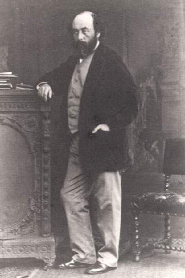
Source: Courtesy of Wikimedia Commons
JUKES, JOSEPH BEETE, geologist and author; b. 10 Oct. 1811 at Summerhill, near Birmingham, England, eldest child and only son of John Jukes and Sophia Beete; m. in September 1849 Georgina Augusta Meredith, and the marriage was childless; d. 29 July 1869 in Dublin (Republic of Ireland).
When Joseph Beete Jukes was only eight years old, his father, a manufacturer, died, leaving a strong-willed widow who was resolved that the lad should be educated for the clergy. Consequently, on completion in 1830 of his grammar school studies at Wolverhampton and at King Edward’s School, Birmingham, young Jukes was sent to St John’s College, Cambridge. Although he pursued classical and mathematical studies, an interest in geology led him to attend the lectures and spirited geological “excursions” of the Reverend Professor Adam Sedgwick. Even before graduating ba in 1836 (he obtained an ma from Cambridge in 1841), Jukes had given up any plans of being ordained. Undecided about his future, he geologized in the midland and northern counties for almost two years, supporting himself by giving public lectures and courses on geology. By 1842 he had become a member of the Geological Society of London.
In 1838 the Newfoundland assembly proposed a geological survey of the colony to search for any valuable mineral resources. Jukes was offered the post of geological surveyor by Lieutenant Governor Henry Prescott* on the recommendation of William Whewell, president of the Geological Society of London. Jukes arrived at St John’s, Nfld, on 8 May 1839, and spent that month familiarizing himself with the local geology and investigating supposed coal occurrences (one on the outskirts of St John’s proved to be slaty rock and the other near Harbour Grace was bog iron). During a visit to Bell Island late in May, he failed to identify its valuable iron ore deposits and instead mapped them as “reddish stone.”
Prior to 1839 Newfoundland’s coastline had been carefully charted by Royal Navy hydrographers but the interior was virtually unknown except for the single track of William Eppes Cormack’s crossing from Trinity Bay to St George’s Bay in 1822. The lack of maps combined with the difficulty of rugged inland travel satisfied Jukes that he would have to restrict his efforts to coastal regions. The legislature increased the original survey grant to permit the chartering of the Beaufort, a 37-ton ketch, which on 16 June sailed out of St John’s harbour. The shoreline and islands of Conception and Trinity bays were mapped and prospected during a five-week cruise, but the search for ore proved fruitless. On learning this disappointing news, Governor Prescott advised Jukes to proceed to Newfoundland’s west coast where coal was known to occur. It was politically expedient that the survey produce results as soon as possible in order to justify its cost. On 30 July the Beaufort headed for the west coast. In early September Jukes, guided by a Micmac named Sulleon, located coal on a small creek near upper Grand Pond (Grand Lake). Nine days later a west coast settler led Jukes to a second coal location near Barachois Brook. Jukes returned to St John’s in mid November and before the year was out submitted to the governor a slim folio entitled Report on the geology of Newfoundland.
On 3 March 1840 Jukes and a Norwegian naturalist, Dr Stüwitz, left St John’s and sailed to “the ice” on the sealer Topaz to find out if ice floes contained the same kind of boulders as those found in diluvium (they are now known to originate from glaciers). While Jukes was still at sea a supply bill including road and survey appropriations was rejected by the Council in the political conflict between that body and the assembly, but eventually Governor Prescott persuaded the house to vote £450 to provide for the continuance of Jukes’ salary and survey expenses. The 1840 mapping programme began with a survey of southern Avalon Peninsula and Placentia Bay, followed by geological exploration of the northeastern coastline from Brigus on Conception Bay to the Bay of Exploits. Jukes ascended Exploits River as far as Great Falls (Grand Falls) in company with John Peyton of Toulinguet (Twillingate). In mid October Jukes was back in St John’s, and then returned to England.
In his full geological report, which first appeared in London in 1842 as part of his Excursions in and about Newfoundland, Jukes acknowledged that “the practical results of this survey are but few, and . . . rather of a negative . . . character,” though he thought they might be useful “in restraining rash speculation.” The Newfoundland assembly’s attempt to publish his geological report separately was vetoed by the Council, but it appeared in 1843 under the financial sponsorship of Lieutenant Governor Sir John Harvey*, who had succeeded Prescott.
Jukes’ accomplishments as geological surveyor of Newfoundland had established his professional reputation. In 1842 he was attached as naturalist to a surveying expedition in Australasian waters. Shortly after his return to England in 1846, he was appointed to the Geological Survey of Great Britain, and in 1850 he accepted the local directorship of the Irish branch of the Geological Survey. Though he came to dislike administration, for 19 years he directed the preparation of more than 40 memoirs on the geology of Ireland. In a landmark paper published in 1862 Jukes demonstrated the importance of stream (fluvial) erosion compared with the lesser role of marine (wavecut) erosion in the genesis of recent landscapes. This contribution along with later studies by American geologists in the western United States laid the foundations of geomorphology. In 1853 Jukes had become a fellow of the Royal Society. In 1866 he was appointed to the British royal commission on coal. A head injury suffered in a fall in 1864 triggered a decline in Jukes’ health, and on 29 July 1869 he died in Dublin. His friend Thomas Huxley memorialized him as “an upright, generous man, of considerable scientific powers.”
Jukes’ geological report on Newfoundland had no apparent effect on island history or on future geological work in the colony; Sir William Logan* rarely referred to his work, and in 1864 James Richardson* spoke of Newfoundland as geologically a “new field.” Jukes’ work was purely a preliminary reconnaissance, and surveyors, legislators, civil servants, and entrepreneurs in the colony appear to have found it of little value. Jukes’ principal legacy to Canada is a valuable record of Newfoundland society in 1839–40. He came into contact with Micmacs, mummers, cod fishermen, and seal hunters, and reported on the hospitality of the colony’s inhabitants from the humblest outport to the governor’s mansion. He was struck by the coarse, primitive manners and customs and the plain, rugged lives of the people, but unlike some other observers he concluded that “the mass of the people are not habitual drunkards.” Despite some disappointment with the “want of manly independence and self-reliance” of the lower classes, whom he felt were too easily led, he found Newfoundlanders “simple, honest, industrious, goodnatured and hospitable” with “the virtues of all hardy races exposed to the toils and dangers of the adventurous life.”
J. B. Jukes was a prolific writer. A bibliography of his published works can be found in Letters and extracts from the addresses and occasional writings of J. Beete Jukes, ed. [C. A. Jukes (Browne)] (London, 1871). His writings relating to Newfoundland include: Excursions in and about Newfoundland, during the years 1839 and 1840 (2v., London, 1842); General report of the Geological Survey of Newfoundland, executed under the direction of the government and legislature of the colony during the years 1839 and 1840 (London, 1843); Report of the progress of the Geological Survey, during 1840 (St John’s, 1840); Report on the geology of Newfoundland, December, 1839 (St John’s, 1839); and “Report on the geology of Newfoundland,” Edinburgh New Philosophical Journal, XXIX (1840), 103–11.
DNB. Mapoteca geologica Americana; a catalogue of geological maps of America (North and South), 1752–1881, in geographic and chronologic order, comp. Jules and J. B. Marcou, (Washington, 1884), 36. E. [B.] Bailey, Geological Survey of Great Britain (London, 1952), 35–36, 41–42, 50, 68–70, 73–76. J. W. Clark and T. M. Hughes, The life and letters of the Reverend Adam Sedgwick . . . (2v., Cambridge, Eng., 1890), I, 521; II, 490. G. L. Davies, The earth in decay; a history of British geomorphology, 1578–1878 (London, 1969), 317–33. J. S. Flett, The first hundred years of the Geological Survey of Great Britain (London, 1937), 55, 59, 76, 92, 116–17. Archibald Geikie, Life of Sir Roderick I. Murchison, bart.; K.C.B., F.R.S.; sometime director-general of the Geological Survey of the United Kingdom, based on his journals and letters . . . (2v., London, 1875), II, 326–29; Memoir of Sir Andrew Crombie Ramsay (London, 1895), 105, 176, 215–18, 294–96. D. W. Thomson, Men and meridians; the history of surveying and mapping in Canada (3v., Ottawa, 1966–69), I, 155. H. B. Woodward, The history of the Geological Society of London (London, 1907), 228–32. [T. H.] Huxley, “Joseph Beete Jukes,” Geological Soc. of London, Quarterly Journal, 26 (1870), pt.ii, xxxii-xxxiv.
Cite This Article
Richard David Hughes, “JUKES, JOSEPH BEETE,” in Dictionary of Canadian Biography, vol. 9, University of Toronto/Université Laval, 2003–, accessed April 25, 2025, https://www.biographi.ca/en/bio/jukes_joseph_beete_9E.html.
The citation above shows the format for footnotes and endnotes according to the Chicago manual of style (16th edition). Information to be used in other citation formats:
| Permalink: | https://www.biographi.ca/en/bio/jukes_joseph_beete_9E.html |
| Author of Article: | Richard David Hughes |
| Title of Article: | JUKES, JOSEPH BEETE |
| Publication Name: | Dictionary of Canadian Biography, vol. 9 |
| Publisher: | University of Toronto/Université Laval |
| Year of revision: | 1976 |
| Access Date: | April 25, 2025 |


